 Photos
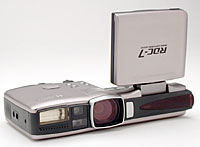
PhotosThe RDC-7 has an interval mode where it will take one photo every 30 seconds. I used that at the beginning. This only makes sense if you can, even if the camera is in interval mode, request extra pictures to be taken (e.g. if you want to make sure that an interesting view is captured). Later, I switched to fully manual operation which requires the release button to be safely accessible while driving, or a remote control.
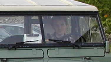 You will need a camera with autofocus and a car that does not
vibrate too much (at least, not more than a 20 year old Land Rover).
I do not know if every autofocus can deal with
shooting from a moving vehicle but the RDC-7's did reasonably well.
You will also have to adjust the camera position
or the zoom setting such that you don't have the car hood in view
all the time. Make sure that the windscreen is clean (if it is
scratchy, select a spot that is as clear as possible), and if
you expect rain, try and install the camera at a position
inside the windscreen wiper range.
You will need a camera with autofocus and a car that does not
vibrate too much (at least, not more than a 20 year old Land Rover).
I do not know if every autofocus can deal with
shooting from a moving vehicle but the RDC-7's did reasonably well.
You will also have to adjust the camera position
or the zoom setting such that you don't have the car hood in view
all the time. Make sure that the windscreen is clean (if it is
scratchy, select a spot that is as clear as possible), and if
you expect rain, try and install the camera at a position
inside the windscreen wiper range.
Most cameras will adjust brightness as they see fit, which can become a problem on a road where you have stretches with a lot of sun and then some in the shade; the resulting image sequence will contain sharp contrasts between dark and light images and you may have to adjust them. (The JourneyMaker and Compiler can do that.)
I guess it is possible to do the same thing with multiple cameras at once, or with one that rotates. This would surely be interesting!
It is vital that the camera records the time at which the photo was taken (with seconds - minutes are not enough). I am not talking of embedding the time into the photo itself, rather of a JPEG header information field that tells you the time afterwards. You will need this to match the photo up with the GPS data afterwards.
As an alternative to the time matching process, you could use a camera that connects to a GPS directly and inquires about the current position when the photo is taken, recording this in a file or JPEG header. I know that this is possible with many of the Kodak digital cameras; they support a BASIC-like scripting language.
Yet an other possibility: Connect the camera and the GPS to a laptop and run a program on the laptop that instructs the camera to shoot a picture and send it over, and at the same time asks the GPS for the current position.
 GPS data
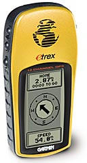
The amount of track points saved depends on whether you set the eTrex to "battery save" mode or not, and also on your eTrex firmware version. With my old firmware version 2.05, my range was about three hours before the memory was full; with the 2.10 firmware it is considerably more (but points are farther apart).
When I download the track log from the GPS (using a program called gd2 written by Randolph Bentson), it looks like this:
63 0d 01 ff 41 43 54 49 56 45 20 4c 4f 47 00 unknown TRK N57 48.116856 W5 40.238428 2001/04/01-10:33:55 1 TRK N57 48.096256 W5 40.319538 2001/04/01-10:35:45 0 TRK N57 48.097544 W5 40.279627 2001/04/01-10:35:46 0 TRK N57 48.061495 W5 40.211391 2001/04/01-10:36:02 0 TRK N57 48.056345 W5 40.203667 2001/04/01-10:36:03 0 [...] |
Again, here it is vital that the time is stored with every fix because that's what you need to match up the data with the photos. The e-Trex has a "save track" function where it will somehow consolidate the track into a structure that uses less memory, deleting some points that lie on a straight line between others, and removing timestamps. Don't use that function.
Some more sophisticated GPSes will allow you to freely set the frequency at which it will record position fixes for the track log. But I saw that some of the more expensive models have actually less memory commited to track logging, so be wary. Also make sure that the GPS doesn't auto power off.
My Land Rover has a lot of holes and thin glazing, so GPS reception inside was not a problem. My guess is that with some modern cars you might be in trouble and you might have to get one of the GPSes with external antennas that can be fitted to the car window with a suction cup.
 Maps
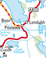
MapsI then found out that I can buy suitable maps (made by Bartholomew) including the license to use them on my website from the streetmap.co.uk website, and did so. They give you a 100km by 100km square as a raster file for about Ł50 per year which is quite reasonable. You might not find similar offers for other countries - often digital map data is horrendously expensive and licenses are based on "number of users" (how many millions on the web...?).
Read more about map troubles on the co-ordinates page.
Besides the obvious (sleep, nutrition, car fuel...) your range will be limited by the following:
If you manage to run the camera from the car battery and carry a laptop, your range is virtually unlimited. This is probably the best way to do it.